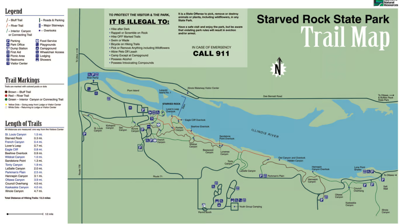
Starved Rock State Park Trail Maps
Starved Rock State Park Trail Maps Suggestions: Average person hikes 1 mile every 30-45 minutes. Please take into consideration the amount of major staircases located at the park. There are no ADA compliable trails into the park’s canyons or overlooks due to the topography.
French Canyon and the brown bluff trail above French Canyon is currently closed. Please use the red marked river trail from the visitor center out to Lovers Leap, Eagle Cliff Overlook,
Wildcat Canyon, and La Salle Canyon for now.
- Less than 1 mile hike:
- Less than 2-mile hike:
- Starved Rock to French Canyon trail map
- 2-2.5 mile hike:
- French, Wildcat Canyons, Lovers Leap, Eagle Cliff Overlooks trail map
- 4-4.5 mile hike:
- 1.5 mile hike:
- Lovers Leap and Eagle Cliff Overlooks Starved Rock Park trail map
- 3 mile hike:
- Aurora and St. Louis Canyon trail map.pdf
- 1, 3, or 10 mile combination hikes:
- Illinois, Ottawa, Kaskaskia Canyons and Council Overhang trail map
- www.kayakstarvedrock.com
- kayakstarvedrock.com/online-booking/
- Starved Rock has a lot of stairs to hike into and out of canyons. It is highly suggested that you wear sturdy supportive hiking shoes, bring hiking poles with you and also carry adequate amount of water for the duration you are hiking.
Starved Rock Trail Closure update 2026
Starved Rock Trail Closures & Construction Update
Beginning the week of March 23, 2026, several trails at Starved Rock will be temporarily closed through June to allow for ongoing trail construction. These improvements will impact access to French Canyon and surrounding areas.
Phase 1 (Late March–June) Closures:
- Access to French Canyon from the Visitor Center and Lodge parking lot/trailhead
- Brown Bluff Trail above French Canyon
- Campanula Trail between French and Wildcat Canyons
Additional Ongoing Closures:
- Tonti Canyon and Tonti Bridge
- West side trail from LaSalle Canyon to Tonti Canyon
- Staircase from the west entrance to the boat ramp
For more details, please visit the Starved Rock Trail Improvement Project page.
Short-Term Closure (March 30–April 2):
The wooden footbridge on the west side of the Lodge, along the Brown Bluff Trail leading to Aurora and St. Louis Canyons, will be closed for repairs.
Visitor Access Note:
During this time, visitors can access the west side of the park by using the St. Louis Canyon parking lot off Route 178, located across from Grand Bear Lodge.
Starved Rock State Park is a stunning natural area located in LaSalle County, Illinois, USA. The park is a popular destination for hikers, nature enthusiasts, and anyone seeking to escape the hustle and bustle of city life. With its beautiful canyons, waterfalls, and scenic trails, Starved Rock State Park offers a unique opportunity to experience the beauty of the Illinois River Valley.
Recreation
Hiking is one of the most popular activities in Starved Rock State Park, and for good reason. The park has over 13 miles of hiking trails that wind through lush forests, rocky bluffs, and along the banks of the Illinois River. The trails vary in difficulty, making them suitable for hikers of all skill levels. Whether you are looking for a leisurely stroll or a challenging hike, Starved Rock has a trail for you.
Popular Trails
One of the most popular hiking trails in Starved Rock State Park is the St. Louis Canyon Trail. This trail leads hikers through a narrow canyon and past a stunning waterfall. The trail is just under two miles long and is rated as moderate in difficulty. Hikers can expect to see a variety of wildlife, including birds, deer, and squirrels, along the way.
Another popular hiking trail in Starved Rock State Park is the LaSalle Canyon Trail. This trail is just over two miles long and takes hikers through a scenic canyon with towering walls of sandstone. The trail also features a picturesque waterfall and several smaller waterfalls along the way. The LaSalle Canyon Trail is rated as moderate in difficulty and is a great option for hikers who want to experience the park’s natural beauty.
For more experienced hikers, the park offers several challenging trails, including the Wildcat Canyon Trail and the Starved Rock Trail. The Wildcat Canyon Trail is just over four miles long and takes hikers through the park’s most rugged terrain. The trail features steep climbs, rocky outcroppings, and breathtaking views of the Illinois River Valley. The Starved Rock Trail is just over two miles long and leads hikers to the top of Starved Rock, the park’s namesake. The trail is steep and strenuous, but the views from the top are well worth the effort.
Illinois Valley Gem
Hiking at Starved Rock State Park is a great way to explore the natural beauty of the Illinois River Valley. With its varied terrain and scenic trails, the park offers something for hikers of all skill levels. Whether you are looking for a leisurely stroll through the woods or a challenging hike to the top of a bluff, Starved Rock State Park has a trail that will meet your needs. So grab your hiking boots and head to Starved Rock for a day of adventure and exploration.


